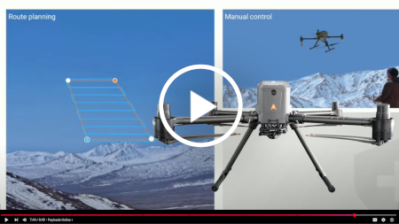
Accessories
EC10 Remote Controller
|
- 5 hour battery life
- Large 10.1-inch
Android touch screen - HDMI out, USB-A
data, USB-C data/9v charging, microSD,
RJ45
- Bright 1000
nits display
- 1920 x 1080 resolution |
 |
|
 |

|
 |
BS10 Charging Station
|
 |
|
1000W max
output, 100-240VAC input
Charge 3 pair
(up to 6) B10 batteries at a time
Active cooling
and smart battery monitoring
Built in 100W
USB-C and 10W 5V USB-A charging ports
User selectable
Standby, Storage, and Standard charge modes
|
 |
|
 |
 |
B10 Smart Battery
|
- B10 battery pair
(2 B10 battery) with X500 package
- 10,000 mAh per
battery, powering X500 58 minute flight time
- 90 minutes to
fully charge a pair of B10 batteries
- Smart charge
indicator, per-cell internal monitoring
|
 |
 |
 |
 |

CHC X500 RTK Quadcopter
with AA15 LiDAR Payload

| |
Payloads
LiDAR Payloads
|
SPECIFICATION
|
AA450
[
Photos
] |
AU10
[
Photos
] |
AA15 |
|
|
 |
 |
 |
|
Datasheet |
[ AA450 ] |
[ AU10
] |
[ AA15 ] |
|
Sample
Data |
[ AA450 & AU10 Comparison
] |
|
|
Price [
Pricing ] |
$14,999 |
$35,000 |
Call |
|
Weight (kg)
|
1.068
|
1.098
|
2.5
|
|
Approx. Max Range (m)
|
100
|
120
|
1800
|
|
Point Rate (pts/sec)
|
240-720k
|
640k-1.28M
|
2M
|
|
Est. Pt Density @ 100m (pts/m²)
|
218
|
115
|
400-600
|
|
Absolute Accuracy (cm)
|
5-10
|
3-5
|
2-5
|
|
Returns per Pulse
|
3
|
3
|
16
|
|
FOV
|
75°
|
70.4°×4.5°
|
360°×40°
|
|
Camera
|
26MP
|
24.3MP
|
45-61MP Optional
|
|
Est. X500 Flight Time (min)
|
52
|
52
|
48
|
RGB Camera Payloads
|
SPECIFICATION
|
C5 ORTHOGRAPHIC
|
C30 OBLIQUE
|
|
|
 |
 |
|
Datasheet |
[ C5
] |
[ C30
] |
|
Price [
Pricing ] |
$10,019 |
$18,199 |
|
Weight (g)
|
290
|
605
|
|
Sensor Type
|
Full-frame
|
APS-C x 5
|
|
Total Resolution (MP)
|
45
|
130 (26 x 5)
|
|
Focal Length (mm)
|
35
|
25/35
|
|
FOV/Angle
|
54.3° x 37.8°
|
45°/90°
|
|
Storage (GB)
|
256 Internal
|
640 External
|
|
Transfer Speed (Mb/s)
|
80
|
300
|
|
Power (W)
|
10
|
25
|
|
Primary Application
|
Orthomosaic/DSM
|
3D Modeling
|
|
GSD @ 100m (cm)
|
1.2
|
1.5
|
| |
|
 

[
View all X500 images
]

Ready to start collecting aerial data? [
Contact our expert team ]
|
| |
CoPre Post Processing
Advanced software to geo-reference, quality check, and
export point clouds
[
Pricing ]
Unified Hardware and Software Workflow
CoPre post-processes inertial data from CHC
LiDAR and Camera payloads. Fast data processing with
wizard and NAD83(2011) coordinate zone selection.
|

|
 |
Lifetime Point Cloud
Colorization and Processing
Local, desktop based
processing
-
Advanced post-processing of GNSS+IMU data for
better accuracy
-
Full NAD83(2011) and GEOID support
-
Capability to process multiple datasets
simultaneously
-
Point cloud visualization and coloring
-
Compatible with Windows 10/11 x64 and Nvidia
graphics cards
|
Easy
Georeferencing and Quality Control
-
RTK or PPK base station input
-
Import and report vs. GCPs
-
X,Y,Z cut and clip to check for noise
or cleanup area of interest
-
Process large datasets efficiently
without intervention
-
CoPre processes aerial data and the
same robust user interface processes handheld SLAM
in GNSS-denied areas
|
 |
 |
Export Colorized
Clouds for Extraction
Coordinate system transformations,
conversion between worldwide and projected coordinate
systems
Measurement and slicing tools for analysis
Seamless integration with existing point
cloud workflows
Export .LAS colorized for further
processing and extraction |
|
X500 RTK Drone Pricing
iGage X500 RTK Drone Package
Part # |
Description |
Images
[
View all
] |
Price |
|
8005010155 |
X500 RTK Drone
- Landing legs
- Spare controller antennas
- Spare propeller pair
- 36" Precision Landing pad
- Transport container |

 |
|
|
201051399
EC10
4104060050
9v USB-C Charger |
EC10 Remote Controller
- 110VAC -> 9v 4a USB-C charger |
 |
Standalone:
$2,808 |
|
201051284 |
B10 Battery Pair
- Two (2) B10 10,000 mAh battery |
|
Standalone:
$2,598 |
|
201051419 |
BS10 Charging Station
- Hard rolling case, capacity six (6) B10 battery
|
|
Standalone:
$1,699 |
|
iGage X500 Package Price (X500 +
EC10 + B10 Pair + BS10) |
$16,996 |
LiDAR + RGB Payload
Pricing
Part #
|
Description
|
Images
[ View all ] |
Price
|
|
8005010044 AA450 |
AlphaAir 450 Lidar System (Alphaport)
[ AA450 &
AU10 Comparison ]
- SPECIAL:
Includes CoPre2 Standard license, a value of $1,200 |
|
$14,999 |
|
S2020209A660004001 AU10 |
AU10 Lidar System (Alphaport) [
AA450 & AU10 Comparison
] - SPECIAL:
Includes CoPre2 Standard license, a value of $1,200 |
|
$35,000 |
|
8005010157 AA15L |
AA15L Lidar System (Alphaport) -
Optional C5 or C30 camera available - Requires
extended landing legs - Requires CoPre2 Standard
license below |
|
Call |
|
201051400 |
X500 Extended Landing Gear (pair) |
|
$520 |
|
8005010086 |
C5 Orthographic Camera (Alphaport) |
|
$10,019 |
|
4109020170 |
C30 Oblique Camera (Alphaport) |
|
$18,199 |
|
4109020170 |
C504 Gimbaled Camera (Alphaport) |
|
$12,999 |
Point Cloud Post Processing Software
Licensing
Part # |
Description |
Images |
Price |
|
8005010084 |
CoPre2 Standard Version Package
(Permanent)
Standard post-processing colorized LAS,
quality check and report, export LAS in coordinate
system |
|
$1,200 |
|
4109020177 |
CoPre2 Airborne 3D Modeling Addon (Permanent) Optional post-processing license enabling 3D meshes
from point cloud + aerial oblique imagery |
|
$2,800 |
|
4109020089 |
CoPre2 Airborne 3D Modeling Addon (1-year) Optional post-processing license enabling 3D meshes
from point cloud + aerial oblique imagery |
|
$1,000 |
|
|
CHC X500 Drone Frequently Asked Questions
1) Do you offer weekly rental, monthly rental, charter or aerial services?
iGage does not offer charters, rentals, or services for the X500, payloads, or any aerial products.
2) What are the licensing or legal requirements for operating a commercial drone?
In the United States, commercial drone operations fall under the FAA Pt. 107 program. Businesses should also purchase Commercial General Liability insurance for the operation of the aircraft, as well as Hull or Inland Marine Insurance covering the aircraft and payload.
3) What are the costs beyond the initial hardware investment?
Often overlooked costs in addition to the drone are:
Software and licensing, where will you take the georeferenced LAS and extract a DXF or surface? There are many great extraction softwares on the market.
Batteries, depending on your size of job, you may want multiple pairs of battery.
Insurance, general liability, inland marine.
Crew training, getting someone Pt. 107 licensed is one step, consider purchase or operation of small photogrammetry drone for trial period. During learning, rule of thumb says you will spend 20% of time in field collecting, and 80% in office extracting data.
Processing hardware, high-end workstation for point cloud processing
4) What is the best workflow for survey deliverables?
In general, your data will go from:
1) Raw point cloud, not trajectory post-processed.
2) Trajectory post-processed, export georeferenced point clouds or meshes, this software is provided by sensor manufacturer, such as CoPre2. Export colorized .LAS point cloud.
3) Take exported .LAS point cloud, and extract surface (topography) or planimetrics (linework, DXF), this can be done in any number of third-party
software, and almost all offer a 14-30 day free trial.
Extraction software examples include:
3D Survey,
Virtual Surveyor,
Pix4D Survey,
Global Mapper, and
Carlson Point Cloud.
5) What are the limitations with dense vegetation and challenging terrain?
Various payloads and sensors are available based on job conditions. Ground control and check shots will need to be collected to verify results. Water bodies cannot be surveyed with traditional LiDAR sensors. Snow cover can affect accuracy and large bodies of grass may completely occlude the ground and make measuring difficult or impossible.
Aerial mapping offers a new measurement perspective, the ability to collect data in inaccessible places, and makes it possible to collect hundreds of acres in a day. Consider a SLAM LiDAR scanner
like the [ RS10 ]
for wastewater/storm water manholes, inverts, culverts
and under obstructions like bridges.
|
| |
Nationwide Support and Sales Team
|
iGage has functional and regional teams providing industry
leading support and service for GNSS, optical, SLAM, Machine
Control, uncrewed marine and aviation survey vehicles.
[
click for regional information
]
|
Contact Us


How can
we help? [ Get in touch
with our team ]
|
|
|
| |